


Ronce les bains phare de la Coubre

taguette
User
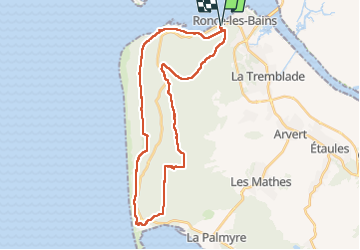

Length
34 km

Max alt
59 m

Uphill gradient
370 m
Km-Effort
39 km

Min alt
3 m

Downhill gradient
370 m
Boucle
Yes
Creation date :
2023-01-04 07:49:48.632
Updated on :
2023-01-04 15:53:08.797
7h13
Difficulty : Difficult

FREE GPS app for hiking
 SityTrail
IGN / Geographical institutes
SityTrail Plus
The world is yours!
About
Trail Walking of 34 km to be discovered at New Aquitaine, Charente-Maritime, La Tremblade. This trail is proposed by taguette.
Positioning
Country:
France
Region :
New Aquitaine
Department/Province :
Charente-Maritime
Municipality :
La Tremblade
Location:
Unknown
Start:(Dec)
Start:(UTM)
641897 ; 5072683 (30T) N.
Comments